


The Indian Ocean Region is the theatre where India’s strategic future will be contested, and it is also the hardest place on earth to watch. The area of interest runs from the Gulf of Aden to the Malacca Strait, across tens of millions of square kilometres of open water.
Somewhere inside it, at any given hour, are the vessels that matter: a research ship loitering over a cable route, a fishing fleet operating as a militia, a warship that has gone dark. Finding them is the defining intelligence problem of maritime India. It is, quite literally, a search for a needle in a haystack, and the haystack is the size of an ocean.

For two decades the instinctive answer has been more imaging. Optical and synthetic aperture radar satellites deliver extraordinary pictures, and India has built genuine strength here. But an imaging satellite is a microscope. It resolves a target beautifully once it is pointed at the right patch of sea, and it sees nothing at all when it is pointed at the wrong one.
The scarce resource in space-based surveillance is not resolution. It is knowing where to look. A constellation that spends its passes photographing empty water is not persistent surveillance. It is expensive luck.
This is where radio frequency sensing changes the architecture rather than merely adding to it. Almost everything of interest at sea emits electronic exhaust: navigation radars, communication links, identification transponders, the electronic exhaust of a functioning vessel.
When a vessel “goes dark,” it is silencing its identification transponder, not its ship. The navigation radar still sweeps, the communications links still reach for shore, the electronic signature of a working hull persists.

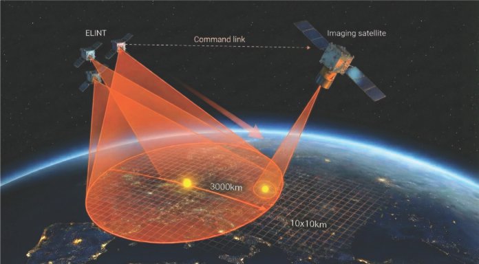
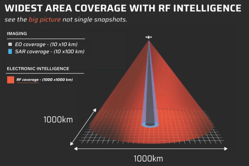
The act of concealment that defeats cooperative tracking is precisely the act that leaves a vessel radiating to a passive listener overhead. Going dark, in other words, is not going silent. A passive RF payload does not photograph the sea. It listens to it, across a footprint far larger than any imaging swath, and it maps where electronic activity is concentrated and where signatures do not match declared identity.
RF sensing is the magnifying glass held over the whole scene. It will not tell you the hull number, but it will tell you, quickly and across a very wide area, where the hull worth photographing actually is.

Finding “dark vessels” – ships that deliberately turn off cooperative transponders to mask their identities – across tens of millions of square kilometers is India’s defining maritime intelligence challenge
Read together, the two sensing modes describe a hierarchy that the current Indian architecture has largely inverted. RF should be the first layer, the wide area detector that surveys continuously and cheaply.
Imaging should be the second layer, the confirming instrument that is cued precisely to a location RF has already flagged. Detection, in other words, should drive collection. When it does, the intelligence cycle compresses dramatically, because the imaging satellite is no longer searching. It is confirming.
This is not a hypothetical scenario. In late 2023, as attacks on shipping in the southern Red Sea intensified and vessel after vessel switched off its transponder to avoid association with the traffic, commercial space-based RF sensing continued to detect and track those ships across a search area of some three hundred thousand square kilometres.
The transponders went dark. The vessels did not. A single wide-area RF collection over open water found the hulls that the cooperative picture had deliberately lost.
The compression is the point. The value of surveillance is not the image; it is the decision the image enables, delivered while the decision still matters. Today that loop typically runs through the ground.
A sensor collects, downlinks to a station, an analyst reviews, a tasking order is generated, a second satellite is scheduled, and the target, if it was moving, has moved. The observe-orient- decide-act cycle that doctrine treats is the measure of operational tempo as measured in hours and days, most of it spent waiting for the next ground contact.
An architecture in which detection and cueing happen on orbit removes the longest legs of that wait. An RF satellite that detects an anomaly can pass a cue to an imaging asset over an in theatre link, with a human on the loop rather than a ground station in the critical path. The loop shrinks from days toward minutes.
This is not an argument for removing human judgment from consequential decisions, and it is not autonomy for its own sake. It is an argument about latency. In the grey zone, where advantage is measured in how quickly you can characterise an ambiguous contact, latency is the whole game.
None of this is theoretical for India, and this is where the capability question becomes a sovereignty question. Maritime domain awareness built on foreign feeds is awareness held at the sufferance of the provider.
The signals of interest, the geolocation, the pattern of life over India’s own waters, these are national intelligence products, and they cannot sit inside architectures India does not control.
The case for building space-based RF sensing indigenously is not primarily industrial. It is this category of intelligence, over this ocean, which must be sovereign by construction.
That requirement happens to arrive at a moment when the Indian ecosystem can meet it. The regulatory opening created by IN-SPACe, the pull from iDEX and the services, and the emergence of deep technology startups willing to build hard physics rather than software wrappers have together made it possible to develop payloads of this class in India, on Indian timelines, for Indian requirements.
This is what the transition from jugaad to precision actually looks like in practice. It is not frugal improvisation celebrated for its own sake. It is a small number of teams choosing to solve a genuinely difficult sensing problem to a standard the mission demands, because the mission will not forgive anything less.
Relying on foreign intelligence feeds risks national security. Driven by initiatives like IN-SPACe and iDEX, domestic deep-tech startups are shifting from jugaad (frugal improvisation) to precision physics to build an indigenous, uncompromised surveillance layer
The strategic window is narrow. The countries that will dominate maritime intelligence in the coming decade are the ones deciding their sensing architecture now, and the default gravitational pull, in India as elsewhere, is toward more imaging because imaging is legible and its outputs are photogenic.
That pull should be resisted. Persistence is not achieved by adding satellites and hoping they happen to look at the right square of ocean. It is achieved by putting a detector in front of the camera.
The needle has not become easier to find. The haystack is still the size of the Indian Ocean, and it is filling with more electronic activity, more dark vessels and more deliberate ambiguity every year.
What has changed is that India no longer has to search the whole haystack. It can build the layer that points to where the needle is, and it can build it here.
The question is whether the architecture decisions being taken now reflect that, or whether the country will keep buying microscopes and hoping to get lucky.

The writer is Co-founder and CEO, ULOOK Technologies. The views expressed are of the writer and do not necessarily reflect that of Raksha Anirveda