

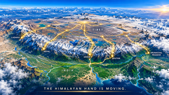
The Hand on the Himalayas: The Himalayas can be read as a mountain wall, a civilisational frontier or a military theatre. This region can also be imagined as a strategic hand: Tibet as the palm, with five geographical extensions towards Ladakh, Nepal, Sikkim, Bhutan and Arunachal Pradesh. The metaphor of the ‘Five Fingers of Tibet’ has acquired considerable currency in Indian strategic discourse. Yet its attribution to Mao Zedong as a formal doctrine is disputed; recent scholarship finds little evidence that Mao articulated or China officially adopted it as a strategy. That caveat matters. The value of the metaphor lies not in proving an old doctrine, but in examining a persistent geography. The question today is, therefore, not whether China is mechanically implementing five fingers, but whether the spaces represented by those fingers remain strategically connected to the Tibetan palm.
The Palm: Tibet
Tibet is the geographical centre of gravity of this Himalayan equation. Its plateau provides China with strategic depth, observation advantage and a direct approach to South Asia. Since Tibet’s incorporation into the People’s Republic of China, it has been transformed through roads, railways, airfields, communications networks and logistics infrastructure. These assets have consequences far beyond civilian development. They increase the speed with which China can move forces, supplies and equipment towards sensitive border sectors, while strengthening Beijing’s administrative reach across exceptionally difficult terrain. China’s infrastructure development on the Tibetan plateau has also been assessed as having significant dual-use and military implications.

Tibet’s significance is, therefore, not merely territorial. It is infrastructural, military, economic and political. The plateau connects Xinjiang in the west with Sichuan and Yunnan in the east, while its southern edge confronts India, Nepal and Bhutan. China’s infrastructure strategy increasingly gives this geography operational depth. The palm matters because it gives the fingers coherence. Without Tibet, the five-finger metaphor is only a map. With Tibet transformed into a heavily connected strategic platform, the map acquires operational meaning.
Sikkim is strategically compressed geography. The Chumbi Valley, wedged between Sikkim and Bhutan, brings Chinese territory close to the Siliguri Corridor and creates a direct connection between Himalayan military geography and India’s vulnerable northeastern gateway
The Five Fingers
- Ladakh — The Western Finger: Ladakh is the westernmost and perhaps the most direct military expression of the Himalayan contest. The region links the Tibetan plateau with Xinjiang and overlooks critical approaches towards India. The disputes around the Line of Actual Control have demonstrated that geography alone does not determine security; infrastructure, logistics and the ability to sustain forces at altitude are equally decisive. Chinese road construction and dual-use infrastructure on the plateau strengthen mobility and endurance close to contested areas. For India, the lesson is stark: the western finger cannot be viewed as an isolated border problem. It is connected to China’s wider western theatre, its strategic communications and the military architecture of the Tibetan plateau.
- Nepal — The Central Finger: Nepal occupies a different strategic space. Its importance derives less from direct territorial confrontation and more from connectivity, economic engagement and Himalayan access. China’s expanding infrastructure and connectivity initiatives have increased Beijing’s presence in a country traditionally located between two major powers. Nepal, however, is not a Chinese appendage. Kathmandu retains its own interests, political choices and sensitivities. India’s challenge is, therefore, not to frame Nepal as a contest that Nepal must choose, but to remain a credible, responsive and mutually respectful partner. The Central finger is ultimately about influence, connectivity and strategic autonomy rather than conventional military control.
Arunachal Pradesh is the eastern extremity of the traditional five-finger formulation and remains a major point of contention. China claims the territory as ‘Zangnan’ or ‘South Tibet’
- Sikkim — The Narrow Finger: Sikkim is strategically compressed geography. The Chumbi Valley, wedged between Sikkim and Bhutan, brings Chinese territory close to the Siliguri Corridor and creates a direct connection between Himalayan military geography and India’s vulnerable northeastern gateway. The Doklam crisis demonstrated how a seemingly remote plateau can acquire significance far beyond its immediate location. Sikkim, therefore, cannot be assessed solely through the India-China border. Its importance emerges from the interaction among China, Bhutan, India’s Northeastern connectivity and the approaches to the Siliguri Corridor. Here, terrain, infrastructure and political geography converge in an unusually concentrated strategic space.
- Bhutan — The Pressure Point: Bhutan represents perhaps the most delicate finger because its strategic significance is inseparable from its relationship with India. Chinese territorial claims and boundary negotiations have implications beyond the disputed areas themselves, particularly around the Doklam region. For Beijing, gaining strategic space in the Western Bhutanese sector could alter the geometry confronting Sikkim and the Siliguri Corridor. For India, Bhutan’s security cannot, therefore, be treated as a narrow bilateral issue. Yet Bhutan must retain agency over its own foreign and security choices. India’s objective should be to strengthen Bhutan’s resilience, connectivity and strategic confidence without reducing Thimphu to an instrument of Indian policy.
- Arunachal Pradesh — The Eastern Finger: Arunachal Pradesh is the eastern extremity of the traditional five-finger formulation and remains a major point of contention. China claims the territory as ‘Zangnan’ or ‘South Tibet’ and has repeatedly sought to reinforce its claim through official statements and the renaming of places. India rejects these assertions and maintains that Arunachal Pradesh is an integral part of the country. The strategic significance extends beyond the boundary itself. Tawang, the Eastern Himalayan approaches, and the region’s connectivity give Arunachal military and political importance. Chinese cartographic activity, therefore, forms part of a broader contest involving territory, narratives, infrastructure and international signalling.
India faces a strategic problem larger than defending individual border sectors. The Himalayan frontier is a continuous geographic system, while India’s responses have historically been divided among military commands, diplomatic relationships and administrative jurisdictions
From Doctrine to Instruments
The contemporary significance of the Five Fingers lies in the instruments applied across them. China does not need a single, formally declared doctrine to pursue consistent strategic effects. Its toolkit includes military deployment, dual-use infrastructure, diplomatic engagement, economic connectivity, cartographic assertions, information operations, and administrative consolidation. The combination is more important than any individual instrument.
Infrastructure can alter military geography without firing a shot. Roads and railways improve logistics; airports reduce isolation; communications networks strengthen command and control; civilian settlements can reinforce administrative presence; maps and official names seek to normalise territorial narratives. Diplomacy operates differently in Nepal and Bhutan than military pressure does along the India-China frontier. The instruments vary because the theatres vary.
This is the critical shift from the old metaphor to the contemporary strategic environment. The Five Fingers should not be imagined as five identical territorial objectives. They are five different strategic spaces in which China can employ different combinations of power. The palm provides the geographic foundation; the fingers provide multiple avenues through which influence, pressure and connectivity can interact.

India must accelerate strategic infrastructure across the Himalayan frontier, with roads, tunnels, bridges, airfields and communications designed for year-round resilience rather than episodic connectivity
India’s Strategic Exposure
India faces a strategic problem larger than defending individual border sectors. The Himalayan frontier is a continuous geographic system, while India’s responses have historically been divided among military commands, diplomatic relationships and administrative jurisdictions. China can exploit connectivity between theatres; India must, therefore, improve connectivity between its own responses.
- Geographical: High-altitude terrain magnifies the importance of roads, bridges, airfields, communications and logistics.
- Regional: Nepal and Bhutan possess agency and cannot be reduced to extensions of the India-China contest.
- Narrative: Territorial disputes are fought not only on the ground but also through maps, names, official statements and international messaging.
- Technological: Surveillance, communications, drones, satellites and data increasingly determine how quickly states understand and respond to developments along remote frontiers.
- Institutional Coherence: Border management, foreign policy, intelligence, infrastructure planning and economic diplomacy must reinforce one another.
Strategic patience cannot mean strategic passivity; nor should competition with China become an excuse to weaken relationships with Himalayan neighbours whose confidence is a strategic asset. India, therefore, needs to see the Himalayas as one strategic ecosystem rather than a collection of separate borders. Military preparedness remains indispensable, but it alone cannot answer an infrastructure competition, a connectivity competition or a contest for regional confidence.

India should deepen sustained engagement with Nepal and Bhutan while respecting their sovereignty and strategic autonomy. Credible partnerships are more durable than competitive pressure
What India Must Do
India’s response should be comprehensive and disciplined.
- It must accelerate strategic infrastructure across the Himalayan frontier, with roads, tunnels, bridges, airfields and communications designed for year-round resilience rather than episodic connectivity.
- It must integrate border development with local communities, because populated and economically viable frontier regions provide strategic depth of their own.
- India should deepen sustained engagement with Nepal and Bhutan while respecting their sovereignty and strategic autonomy. Credible partnerships are more durable than competitive pressure.
- India needs an integrated technology architecture combining satellites, drones, sensors, secure communications, artificial intelligence, and rapid decision-making.
- India must contest cartographic and information narratives with facts, diplomacy and consistent communication.
The objective should not be to imitate China finger for finger. It should be to ensure that every Himalayan space has infrastructure, institutions, partnerships and capabilities strong enough to resist coercion and preserve strategic choice.
The Hand is Moving
The Five Fingers may never have been a formal Chinese doctrine, but the geography behind the metaphor remains strategically consequential. Tibet is still the palm; Ladakh, Nepal, Sikkim, Bhutan and Arunachal Pradesh remain connected spaces, although each possesses a different political and strategic character. What has changed is the reach of Chinese power: roads, railways, military logistics, diplomacy, maps, technology and narratives now operate together.
India, therefore, needs more than a border strategy. It needs a Himalayan strategy — integrated, resilient and long-term. The hand is moving; India’s strategic task is to ensure that neither is its response.

Lt Gen Rajeev Chaudhry (Retd) writes on contemporary national and international issues, strategic implications of infrastructure development towards national power, geo-moral dimension of international relations, and leadership nuances in a changing social construct. The views expressed are of the author and do not necessarily reflect the views of Raksha Anirveda