The Indus Waters Treaty (IWT) remains one of the most durable international water-sharing agreements in modern history. Signed on 19 September 1960 by Indian Prime Minister Jawaharlal Nehru and Pakistani President Ayub Khan under the auspices of the World Bank, the treaty survived the wars of 1965, 1971 and Kargil in 1999, as well as decades of bilateral hostility. Yet today, it has become one of the most contentious issues in India-Pakistan relations, with Pakistan warning that any alteration in river flows could constitute an “act of war”, while India argues that the treaty requires reassessment in light of terrorism, climate change and evolving national requirements.
At Partition in 1947, the geography of the Indus Basin created a strategic challenge. The rivers originated in territories that became India, while much of the irrigation infrastructure served areas that became Pakistan. In April 1948, India temporarily suspended water supplies from certain canal headworks following the expiry of a standstill arrangement, triggering the first major water crisis between the two newly independent states.

Recognising that disputes over water could become a permanent source of conflict, the World Bank facilitated negotiations that lasted nearly nine years before the treaty was finalised in 1960.
How the Treaty Divides the Rivers
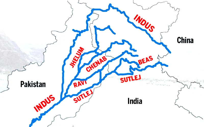
Contrary to popular perception, the treaty does not actually allocate water on a river-by-river basis. Instead, it effectively partitions the six rivers of the Indus system between the two countries.
India received unrestricted rights over the Ravi, Beas and Sutlej rivers, collectively known as the Eastern Rivers.
Pakistan received primary rights over the Indus, Jhelum and Chenab rivers, collectively known as the Western Rivers.

The three Eastern Rivers have a combined average annual flow of approximately 41 billion cubic metres, while the three Western Rivers account for about 99 billion cubic metres annually.
Overall, approximately 80 per cent of the waters of the Indus system were allocated to Pakistan, while around 20 per cent were allocated to India. This reflects the substantially greater flow of the Western Rivers compared with the Eastern Rivers.

India is nevertheless permitted to utilise the Western Rivers for specified non-consumptive purposes, including irrigation, navigation, hydroelectric power generation, floating infrastructure and fisheries, subject to the provisions of the treaty.
The treaty also lays down detailed engineering criteria governing the construction of dams, barrages and other infrastructure on the Western Rivers. Its preamble recognises the respective rights and responsibilities of both countries with the objective of promoting cooperation, goodwill and the optimum utilisation of the waters of the Indus River system.
Despite these safeguards, Pakistan has frequently expressed concern that India could manipulate river flows during periods of conflict by triggering floods or restricting downstream supplies. However, the treaty itself was designed as a water-sharing agreement rather than a national security instrument.
The treaty included a ten-year transition period during which India continued supplying water while Pakistan constructed replacement canals, barrages and reservoirs, including the massive Mangla and Tarbela projects. India also contributed financially to the development of this replacement infrastructure. Remarkably, India continued to honour its treaty obligations even during the 1965 Indo-Pakistan War.
The treaty also established the Permanent Indus Commission (PIC), comprising one commissioner from each country. The Commission exchanges hydrological data, inspects projects and serves as the first institutional mechanism for addressing disputes before they escalate.
Why Are the Chenab and Jhelum So Important?
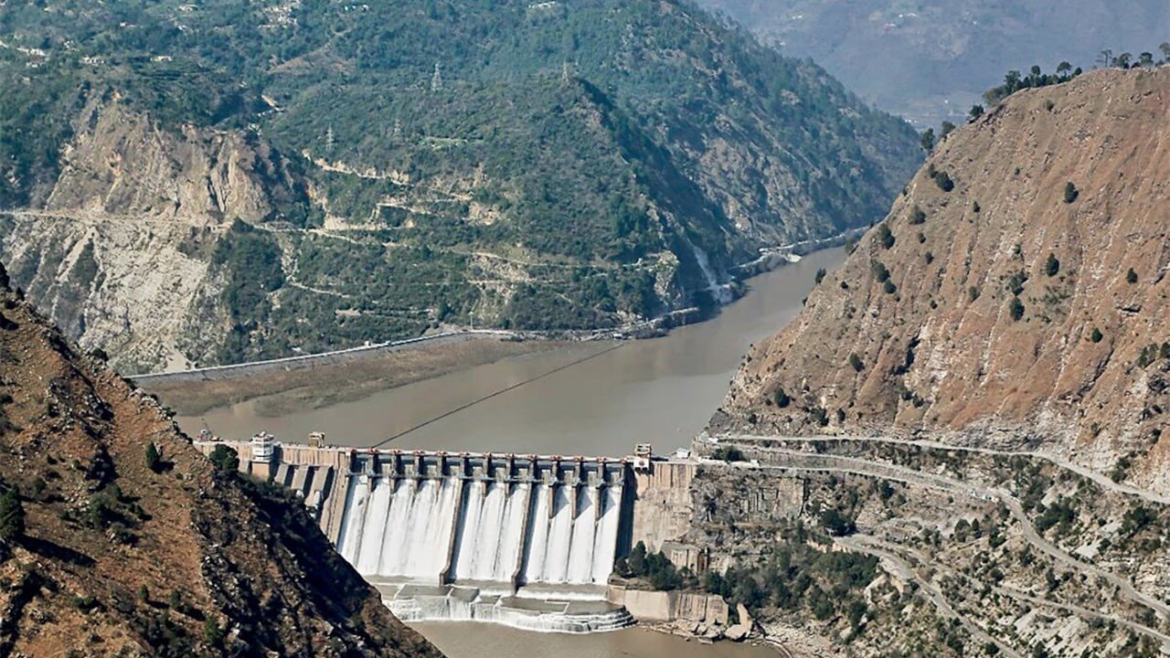
For Pakistan, the Chenab and Jhelum are not merely rivers; they are strategic lifelines. The Chenab irrigates vast areas of Punjab Province, while the Jhelum supports extensive irrigation networks and major reservoirs, including the Mangla Dam. Together with the Indus, these rivers form the backbone of Pakistan’s food security, agricultural economy and hydroelectric power generation.
The Indus Waters Treaty was designed to keep water out of conflict. Today, changing strategic realities are pulling it back into the centre of India-Pakistan tensions
Pakistan’s economy is heavily dependent on the waters of the Indus River system, with approximately 80 per cent of its freshwater withdrawals used for agriculture. Crops such as cotton, which account for more than 60 per cent of Pakistan’s exports and about 8.5 per cent of its Gross Domestic Product (GDP), rely heavily on water from these rivers. Consequently, any significant reduction in water availability during critical cropping seasons could severely affect agricultural output, employment and overall economic stability.
Furthermore, any disruption to river flows could have serious implications for Pakistan’s power sector, which depends on hydroelectric power generated by major projects such as Tarbela, Mangla and Neelum-Jhelum. A sustained reduction in water availability would diminish electricity generation, increase dependence on thermal power and further aggravate Pakistan’s already fragile energy sector, which is burdened by an estimated US$4.4 billion in circular debt.
The consequences extend beyond economics. Pakistan’s dependence on the Indus River system is so extensive that any prolonged disruption could trigger widespread public unrest, exacerbate socio-economic challenges and heighten regional geopolitical tensions.
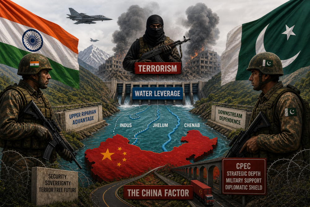
India’s ongoing development of hydroelectric projects on rivers flowing into Pakistan has therefore generated concerns in Islamabad that New Delhi could eventually employ water as an instrument of strategic leverage during periods of heightened tension. Although the treaty imposes strict technical limitations on India’s use of the Western Rivers, these perceptions continue to shape Pakistan’s security discourse.
For India, both the Chenab and the Jhelum flow through the Union Territory of Jammu and Kashmir, making them strategically important for hydroelectric development, irrigation and regional economic growth. Consequently, projects such as Kishanganga, Ratle, Kiru and Pakal Dul have repeatedly become subjects of bilateral disagreement and international arbitration.
Military Operations Around the Chenab and Jhelum
Although no India-Pakistan war has been fought exclusively over the control of a river, the Chenab and Jhelum valleys have repeatedly featured in military campaigns because they influence terrain, mobility, logistics and defensive planning.
The 1947-48 Kashmir War: The first Indo-Pakistan War unfolded largely within the Jhelum basin. Pakistani tribal irregulars advanced along routes linked to the Jhelum Valley towards Srinagar. These river corridors served as natural avenues for movement, reinforcement and logistical support. Consequently, control of bridges across the Jhelum assumed considerable operational significance for both sides.
The successful defence of Srinagar ultimately enabled India to retain control of the upper Jhelum basin, thereby securing one of the most strategically important sectors of the erstwhile princely state of Jammu and Kashmir.
The 1965 War: The 1965 conflict began with Pakistan’s Operation Gibraltar, which sought to infiltrate armed personnel into Jammu and Kashmir in the hope of triggering an uprising against Indian rule.
Much of the fighting occurred in areas influenced by the Jhelum and Chenab River systems. Pakistani offensives in the Chhamb sector sought to exploit terrain west of the Chenab and threaten Indian lines of communication leading to Jammu.
Indian military planners regarded the Chenab as a formidable natural defensive obstacle, while Pakistani commanders viewed crossings and bridgeheads across the river as critical operational objectives capable of influencing the wider campaign.
The 1971 War: Although the principal theatre of war was East Pakistan (present-day Bangladesh), the Western Front also witnessed significant military activity in sectors adjoining the Chenab basin, particularly in Jammu.
River crossings, canals and irrigation networks exerted considerable influence over manoeuvre warfare, troop deployment and defensive planning, demonstrating once again the military significance of riverine terrain.
Kargil Conflict, 1999: The Kargil conflict occurred farther north in the upper Indus basin rather than directly along the Chenab or the Jhelum. Nevertheless, the wider Indus River system continued to influence logistics, troop movement and operational sustainment throughout the campaign.
Control of dominating heights overlooking river valleys remained central to the operational planning of both the Indian and Pakistani armies, underscoring the enduring strategic relevance of the Himalayan River system in high-altitude warfare.
Why Is Pakistan Speaking of War Today?
The present rhetoric emerged after India’s decision in 2025 to place the Indus Waters Treaty in abeyance following the Pahalgam terrorist attack. Pakistan responded by warning that any attempt to stop, divert or substantially alter river flows would be regarded as an “act of war”.
Several strategic considerations underpin Pakistan’s response.
Dependence on Indus Waters
Pakistan’s agriculture remains central to employment, food security and rural livelihoods. Most of its irrigated farmland depends upon the waters of the Indus, Jhelum and Chenab rivers. Consequently, even limited uncertainty regarding future river flows generates significant strategic anxiety in Islamabad.
Pakistan is already among the world’s most water-stressed countries. Rapid population growth, groundwater depletion, inefficient irrigation practices and climate change have all increased the country’s vulnerability to water shortages.
Islamabad fears that India could eventually expand storage capacity and hydroelectric infrastructure on the Western Rivers, thereby acquiring greater ability to regulate the timing of downstream flows, even if a complete diversion of river waters remains technically impossible in the foreseeable future.
For more than six decades, the Indus Waters Treaty has been regarded internationally as one of the few enduring examples of cooperation between two long-standing adversaries. Consequently, its suspension carries political and psychological significance that extends well beyond the actual quantity of water involved.
Lessons from History: When Water Disputes Have Led to Conflict
Although outright wars fought exclusively over water are relatively rare, history demonstrates that competition over rivers and water resources has often been a significant contributing factor in interstate conflicts.
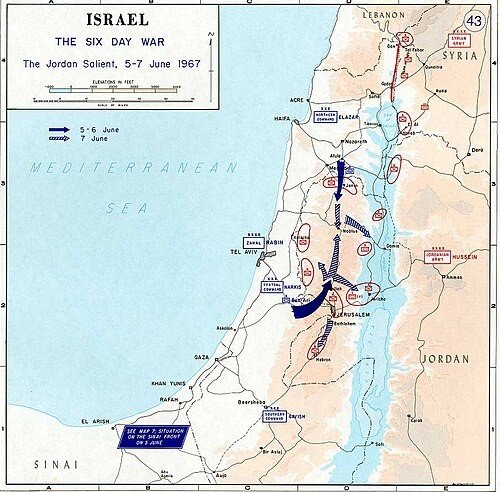
One of the most frequently cited examples is the 1967 Arab-Israeli War, during which tensions over Israel’s National Water Carrier project and Arab attempts to divert the headwaters of the Jordan River became an important element in the deterioration of regional relations. Water security continues to remain a critical dimension of Israeli-Jordanian-Palestinian geopolitics.
The Chenab and the Jhelum are more than rivers—they are strategic assets shaping agriculture, energy security, military planning and regional geopolitics
In Africa, disputes within the Nile Basin have generated prolonged tensions among Egypt, Sudan and Ethiopia, particularly following Ethiopia’s construction of the Grand Ethiopian Renaissance Dam (GERD). Egyptian leaders have repeatedly described unrestricted Nile flows as an existential requirement. Although diplomacy has thus far prevented armed conflict, military options have periodically featured in political discourse.
Similarly, following the dissolution of the Soviet Union, upstream states such as Kyrgyzstan and Tajikistan acquired control over significant water resources, while downstream Kazakhstan, Turkmenistan and Uzbekistan remained heavily dependent upon those flows. The resulting imbalance has periodically led to diplomatic confrontations and military mobilisation.
In the Euphrates-Tigris Basin, Turkey’s extensive dam-building programme under the Southeastern Anatolia Project (GAP) has repeatedly strained relations with Syria and Iraq, both of which have accused Ankara of reducing downstream water availability.
These examples demonstrate that water disputes seldom trigger wars in isolation. Rather, they act as force multipliers, aggravating existing political, territorial, ethnic and security rivalries. The Indus Basin exhibits many of these characteristics. Water alone may not trigger an India-Pakistan conflict, but when combined with unresolved disputes over Jammu and Kashmir, terrorism, military competition and nuclear deterrence, it acquires considerable strategic significance.
The Indus Difference
What distinguishes the Indus Basin from many other international river systems is that it is shared by two nuclear-armed neighbours with a long history of armed conflict.
Unlike disputes involving the Nile, Jordan or Euphrates river systems, India and Pakistan have already fought multiple wars while simultaneously sharing a river system upon which hundreds of millions of people depend.
Consequently, any attempt to employ water as an instrument of coercion would carry implications extending far beyond agricultural losses or economic disruption. Such an action would inevitably be interpreted through the prism of national security, strategic deterrence and regional stability.
This explains why debates surrounding the Indus Waters Treaty frequently generate rhetoric about war, even though India’s practical ability to alter river flows significantly remains limited in the short term.
Water in South Asia is therefore no longer viewed merely as a natural resource; it is increasingly regarded as an element of comprehensive national power, economic resilience and strategic influence.
Can India Actually Stop the Water?
In the immediate future, the answer is no. India currently lacks sufficient storage infrastructure on the Western Rivers to halt water flows into Pakistan completely. The sheer volume of water carried by the Indus River system makes any such action technically impracticable in the near term.
However, India can make progressively greater use of the rights already available under the treaty by expanding dams, reservoirs, irrigation infrastructure and hydroelectric projects that comply with its provisions.
Over the longer term, enhanced storage capacity could provide India with greater flexibility in regulating the timing of water releases. Nevertheless, such regulation would remain subject to engineering constraints, treaty obligations (unless formally modified) and broader geopolitical considerations.
Water alone is unlikely to trigger war, but when combined with terrorism, Kashmir and nuclear deterrence, it becomes a powerful force multiplier in South Asia’s security calculus
Takeaways
The Indus Waters Treaty was designed to remove water from the battlefield. For more than six decades, it largely achieved that objective. Yet the strategic environment has changed fundamentally. Terrorism, climate change, demographic pressures, rising energy demands and expanding infrastructure have transformed water from a technical resource-management issue into a matter of national security.
The Chenab and the Jhelum occupy the centre of this debate because they simultaneously constitute Pakistan’s agricultural lifeline and India’s principal avenues for hydroelectric development in the Union Territory of Jammu and Kashmir. Historically, these rivers have influenced military campaigns, shaped operational planning and served as natural defensive barriers. Today, they are increasingly acquiring geopolitical significance as instruments of strategic signalling.
The likelihood of a full-scale war fought solely over water remains low. However, water has emerged as an additional pressure point within the broader India-Pakistan rivalry, alongside terrorism, cross-border militancy, Jammu and Kashmir, military competition and nuclear deterrence.
The greater challenge for both countries is that the Indus Basin is now confronting the combined pressures of geopolitics, climate change, population growth and rising water demand—a far more complex equation than the one envisaged by the architects of the treaty in 1960.
The future of the Indus Waters Treaty will depend not merely upon legal interpretation but upon the broader trajectory of India-Pakistan relations. As strategic competition intensifies and water security assumes increasing geopolitical importance, both countries will face the difficult task of balancing sovereign interests, environmental sustainability and regional stability.
Whether the treaty ultimately evolves, is renegotiated or continues in its present form, the Indus Basin will remain one of South Asia’s most consequential strategic landscapes, where hydrology, diplomacy and national security are inextricably intertwined.

-The author retired as Major General, Army Ordnance Corps, Central Command, after 37 years of service. A management doctorate and expert on defence modernisation, he is the author of four books, including the Amazon bestseller “Breaking the Chinese Myth,” and a frequent media commentator. He is affiliated with several leading defence and strategic studies institutions in New Delhi. The views expressed are of the writer and do not necessarily reflect the views of Raksha Anirveda