Anaheim/USA. Sensor solutions provider HENSOLDT has announced that its EuroNav 7 mission system for critical airborne applications is now enhanced with the integration of Smith Myers’ award-winning ARTEMIS Mobile Phone Detection, Location, and Communication System.
“This is a winning combination that is making waves in the avionics industry. Tailored for the helicopter elite, this powerhouse duo is more than just a tool. It’s an exclusive pass to a new level of control and safety”, says Michael Gröninger, Managing Director of HENSOLDT Avionics. “This partnership of proven systems is targeting expansion worldwide across a growing customer base deploying essential systems for Search and Rescue (SAR) missions, where every move is executed with precision.”

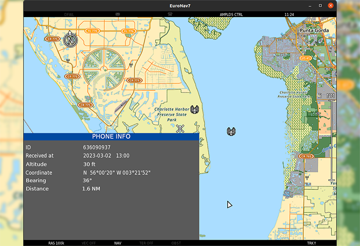
EuroNav 7, integrated with ARTEMIS, stands out in its ability to identify, locate and interact with cell phones. This feature not only enables effective help for people in distress, but also provides first-class support in disaster control and in the fight against people smuggling and supporting other maritime patrol operations. The system also detects the cell phone’s country of origin making it the perfect tool for detecting border intrusions.
“ARTEMIS interacts with and geolocates the cell phone quickly and precisely using the cellular protocol itself. EuroNav 7 displays this information and enables the automatic steering of other sensors onto the cell phone’s location. The location of thousands of handsets can be established very quickly and displayed on EuroNav 7”, explains Andrew Munro, Managing Director of Smith Myers.
EuroNav takes the lead by integrating a full range of operational features that perfectly complement the ARTEMIS system. This combination is now available via the off-the-shelf EuroNav 7 product, making it the ultimate in operational excellence.
- Precision Identification and Location: EuroNav 7 with ARTEMIS allows aircrew to precisely identify and locate cellular handsets with unmatchable speed.
- Enhanced Situational Awareness: The combination of mass mapping and geofencing from ARTEMIS in EuroNav 7, facilitates operations in complex environments.
- Extended Range and Flexibility: With a range of more than 30 km, ARTEMIS and EuroNav 7 extend the limits of use allowing the sensor suite to “see further quicker, and more accurately”.
- Integrated Features: with integrated AIS cellular and maritime data can be overlayed in real time. COSPAS SARSAT identifies and locates emergency and personal locator beacons.
Meet us at HAI 2024 Expo, Booth 6906, and witness EuroNav 7 with ARTEMIS in action on our flight simulator.