
The Afghanistan-Pakistan border, historically volatile and rugged, has become the focal terrain for the latest conflict surge. Since early 2024, and especially during the recent escalation (February 26–27, 2026), engagements have concentrated in multiple frontier sectors where complex terrain intersects with insurgent mobility and geopolitical fault lines.
Clashes and skirmishes can be categorised into three broad tactical zones:

Northwest Sector: Between Torkham and Khyber Pass Corridor
Geographic and Strategic Description. This sector includes the Torkham border crossing, the Khyber Pass mountains, and adjacent tribal hills in eastern Afghanistan and northern Khyber Pakhtunkhwa (KP). The terrain of the region is composed of: Steep mountain ridges (1,500–2,500 m) dominating valley floors, Narrow defiles and passes that restrict manoeuvre space and Sparse infrastructure with limited paved roads. This rugged topography creates natural choke points but also provides avenues for infiltration and insurgent mobility.
Recent Incidents and Engagement Dynamics. On February 26–27, 2026, firefights erupted around forward Pakistani outposts near Torkham and Landi Kotal, triggered by Afghan retaliatory strikes following Pakistani air operations deeper inside Afghan territory. Taliban-aligned and allied militant groups exploited steep ridges and blind valleys to mount indirect fire attacks, ambushes, and rocket barrages on Pakistani positions. Pakistani forces responded with precision artillery and close-air support, constrained by the risk of friendly fire due to converging ridgelines and narrow valleys.
Geographically, this sector includes the Torkham border crossing, the Khyber Pass mountains, and adjacent tribal hills in eastern Afghanistan and northern Khyber Pakhtunkhwa. The terrain includes steep mountain ridges, narrow passes that restrict manoeuvre space, and sparse infrastructure with limited paved roads. This rugged topography creates natural choke points but also provides avenues for infiltration and insurgent mobility
Terrain Challenges and Tactical Implications. Limited Lines of Sight: Steep ridges block observation, making recon difficult and enhancing the defensive advantage of forces occupying high ground. Restricted Manoeuvre Routes: Only a few serviceable roads connect small valleys, forcing heavy vehicles into predictable paths subject to IEDs and ambushes. Elevation and Weather: Sub-zero temperatures and fog impede ISR (Intelligence, Surveillance, Reconnaissance) and precision-guided munitions, reducing the effectiveness of air-ground integration.
Operational Impact. Defensive Advantage to Irregulars: Insurgents use high ground for observation and egress, limiting Pakistan’s ability to dislodge them without high collateral risk. Static Frontlines: Movement is constrained, leading to localised stalemates punctuated by concentrated fire engagements.

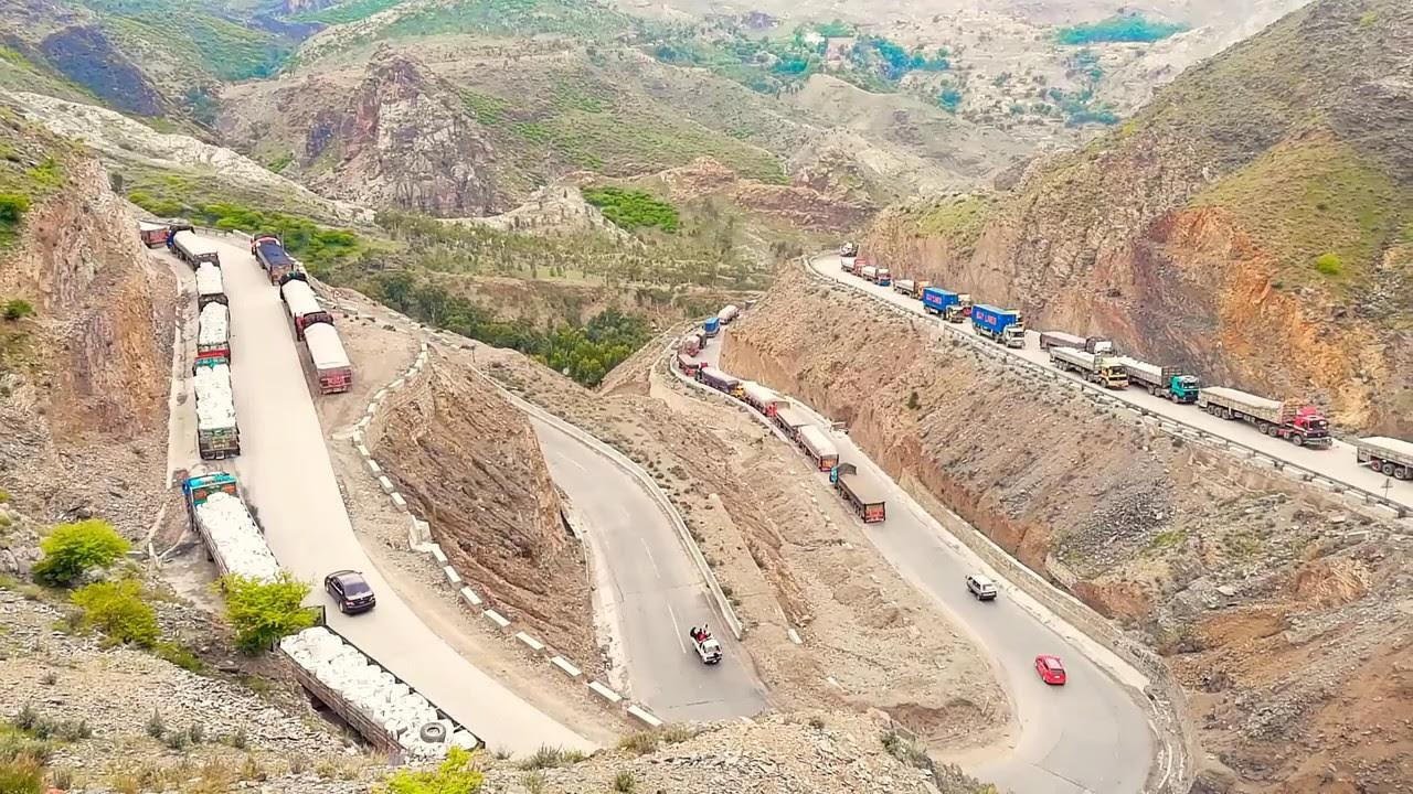
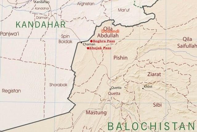
Central Mountainous Sector: Between Spin Boldak–Chaman and Arid Highlands
Geographic Characteristics. The Spin Boldak–Chaman border near Baluchistan features: Arid highlands and rocky plateaus, Sparse vegetation and minimal cover and Open plains between rocky outcrops that allow mechanised movement but expose forces to long-range fire.

Recent Engagements and Dynamics. Before and during the February 2026 crisis, Pakistani forces carried out cross-border air and artillery strikes in the vicinity of Spin Boldak and Qila Abdullah to disrupt insurgent staging areas. Taliban and allied insurgent units responded with indirect fire and mortars targeting Pakistani border posts and FOBs (Forward Operating Bases).
Terrain Challenges and Tactical Analysis. Open Plains: Facilitate faster manoeuvre for mechanised units, but without natural cover, this increases vulnerability to indirect fire and precision strikes. Rocky Plateaus: Provide sporadic concealment for insurgent sniper teams and small ambush detachments. Sparse Infrastructure: Limits resupply and rapid reinforcement, especially at night when spotlight and thermal detection shape operational tempo.
Operational Effects. High-Velocity Exchanges: Open terrain leads to prolonged artillery duels rather than close-quarters engagements and Psychological Strain: Exposed positions increase stress on forward troops and escalate demand for air cover and ISR assets.
Southern Sector: Through Ghazni–Paktika–Bajaur axis
Terrain Features. The southern frontier, particularly near Ghazni and Paktika (Afghanistan), adjoining Bajaur Agency and South Waziristan (Pakistan), consists of: Interlocking ridges and valleys similar to the northwest but with deeper dry riverbeds (khuls), Seasonal wadis and gullies that provide concealed movement corridors and Sparse but strategically important road nodal points
During the recent crisis, Pakistani forces carried out cross-border air and artillery strikes near Spin Boldak and Qila Abdullah to disrupt insurgent staging areas. Taliban and allied insurgent units responded with indirect fire and mortars targeting Pakistani border posts and Forward Operating Bases
Engagement Patterns. Recent Pakistani strikes in this area aimed to disrupt TTP command and control nodes, triggering retaliatory IED attacks and small unit ambushes along Pakistani supply routes and Taliban-linked units have leveraged wadi terrain for concealment and fire staging, complicating counter-operations.
Terrain Impact on Operations. Concealment Corridors: Dry riverbeds facilitate undetected movement of fighters and limpet charges for roadside ambushes. Dispersed Local Populations: Tribal settlements along dry valleys complicate the distinction between civilian and combatant zones, constraining engagement rules.
Operational Consequences. Asymmetric Warfare Environment: Insurgent groups exploit concealed terrain for surprise attacks, forcing Pakistani forces to allocate disproportionate resources to convoy security and route clearance.
Each presents distinct terrain characteristics, operational challenges, and tactical implications for both Afghan forces/Taliban fighters and Pakistan’s military.
Indigenous Knowledge and Local Geography: Force Multipliers
Across all sectors, local combatants — whether Taliban affiliates or tribal militias — utilise generational familiarity with the terrain: Knowledge of micro-terrain features such as ravines, sporadic cliff faces, and watercourses enables unseen movement and encirclements, Seasonal features like flash flood channels act as natural barriers or conduits depending on ground conditions and Locals exploit temperature inversion layers for concealment from aerial ISR around dawn and dusk.
Such indigenous terrain mastery complicates the reliance on technology alone and obliges conventional forces to integrate sustained human intelligence (HUMINT) with terrain-acclimatised combat techniques.
Terrain and Escalation Risk: How Geographic Features Shape Strategic Risk
Difficulty of Surgical Precision. In mountainous passes and high ridges, the proximity of hostile and friendly forces increases the risk of escalation by misidentification. Precision strikes risk civilian harm when terrain blocks clear lines of fire.
Restricted Communication Infrastructure. Communication nodes and command posts in high relief suffer signal shadows and bandwidth limitations, potentially causing coordination breakdowns that escalate tactical encounters into wider engagements.
Knowledge of micro-terrain features such as ravines, sporadic cliff faces, and watercourses enables unseen movement and encirclements. Seasonal features like flash-flood channels act as natural barriers or conduits depending on ground conditions, and locals exploit temperature inversion layers for concealment from aerial ISR around dawn and dusk
Mobility Constraints and Logistical Vulnerabilities. The limited number of supply routes elevates risk to convoys and FOBs, creating opportunities for ambush-induced escalation even during otherwise stabilised periods.
Tactical Recommendations for Managing Border Clashes
Based on terrain-specific challenges, the following measures can improve operational risk management:
Improve ISR Integration with Terrain Modelling. Deploy terrain-aware sensor networks, combining ground-based radar with aerial assets to map likely insurgent routes and blind spots and use digital elevation models (DEMs) to predict no-fire zones and reduce collateral risk.
Enhance Route Security. Implement remote sensor arrays along chokepoints to detect IED emplacement in valleys and narrow passes, and expand engineer reconnaissance units specialised in high-altitude route clearance and obstacle reduction.
Modular Forward Operating Bases. Design FOB layouts that mimic natural cover, reducing visibility from dominant high ground and build redundant communication relays to overcome terrain-induced signal loss.
Operational success and strategic de-escalation both require comprehensive terrain integration, from ISR to logistics to rules of engagement. Without such terrain-sensitive doctrine, efforts to manage and reduce border skirmishes will remain reactive, increasing the risk of broader escalation triggered not by political calculation but by the unforgiving realities of geography
Terrain-Informed Rules of Engagement (ROE). Incorporate terrain buffers into fire control measures, especially in defiles and ridge lines where friendly and hostile forces may be nearby and employ non-lethal area denial systems in high-risk blind valleys to slow insurgent movement without full kinetic engagement.
Conclusion: Terrain as Determinant and Constraint
The Afghanistan-Pakistan border is not only a geopolitical fault line but a topographical crucible where terrain dictates the tempo, intensity, and type of military engagement. The current hostilities — particularly concentrated in the Torkham–Khyber, Spin Boldak–Chaman, and Ghazni–Paktika corridors — illustrate how mountain massifs, narrow passes, arid plains, and concealed wadis shape the conduct of warfare.
Operational success and strategic de-escalation both require comprehensive terrain integration, from ISR to logistics to rules of engagement. Without such terrain-sensitive doctrine, efforts to manage and reduce border skirmishes will remain reactive, increasing the risk of broader escalation triggered not by political calculation but by the unforgiving realities of geography.

-The author retired as Major General, Army Ordnance Corps, Central Command, after 37 years of service. A management doctorate and expert on defence modernisation, he is the author of four books, including the Amazon bestseller “Breaking the Chinese Myth,” and a frequent media commentator. He is affiliated with several leading defence and strategic studies institutions in New Delhi. The views expressed are of the writer and do not necessarily reflect the views of Raksha Anirveda
