 A satellite can be used for many military purposes. Primarily, military satellites are used for Communication, Intelligence, Surveillance & Reconnaissance, Navigation, Meteorological Observations and Electronic Warfare. Theoretically any satellite, can carry out these functions whether it is in High, Geostationary, Mid or Low Earth orbits. However, from a practical point of view it is the Low Earth Orbit (LEO) which is most commonly used for military satellites. It is highlighted at the outset that understanding LEO is more important for exploiting space rather than knocking a satellite down. The LEO is the simplest, cheapest and safest location for the deployment of satellites, space stations, and crewed space missions. Most military personnel do not understand the fundamentals of a LEO and hence are at a loss to appreciate the essentials of ASAT tests and their implications. In this context this article is an attempt to give readers a basic understanding of LEOs and their utility as military platforms.
 Height
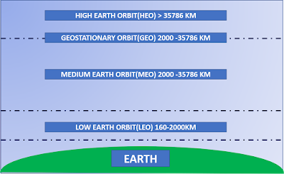
A Low Earth Orbit Satellite is one that is in orbit 160 -2000 km above the earths surface. Any object below 160 Km suffers from a phenomenon called orbital delay and descends into the atmosphere to burn or crash land. In practice, LEO satellites orbit between 300 -1000km. The reason being that below 300km the drag is high, and it is difficult to maintain a satellite at that altitude. Above 1000km there are something called Van Allen radiation belts which are zones of charged particles. They cause a lot of ionospheric interference and endanger satellites which invariably have sensitive equipment. A major factor in deciding the height of the satellite is the bandwidth available for operations and the latency (communications time lag). A LEO satellite gives the best results for this.

 Orbits, Polarity and Speed
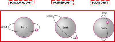
LEO satellites can also be on an equatorial orbit, inclined orbit or a polar orbit. In an equatorial orbit, the area covered is a latitudinal band only. Normally LEO satellites are kept in Polar or Inclined orbits which enables max coverage of the Earth. A polar orbit is essentially a north south orbit around the poles. The earth revolves west to east. The satellite orbit and the earth’s rotation allow it to cover most of the earth surface after it has covered a complete cycle of orbits in a certain period. Orbits can be circular or elliptical. Circular orbits are popular, because then the satellite is at a constant altitude requiring a constant strength of signal to communicate. Elliptical orbits are useful to increase the stay period over an area.
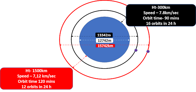
LEO satellites orbit the earth at an average speed of 7.8 Km/ sec when their altitude is 300 km. As the altitude increases to about 1500 km, the speed reduces to 7.12 km/sec. They circumvent the Earth in 90 minutes to 120 minutes (approx.). It means that a LEO satellite circumvents the earth 16-12 times a day depending upon the height at which it is placed. Lower the orbit height, higher is the number of orbits and vice versa. As a thumb line guide, a LEO satellite will traverse the entire length of Pakistan (north to south) in about 7-8 minutes. By the time the satellite finishes one orbit of 90 minutes, Pakistan would have passed by underneath. Some part of Iran would be directly below the satellite. Twelve hours later, Pakistan will be once again under the satellite for about 7-8 minutes. Hence in a 24-hour period, Pakistan would have been seen for 14-16 minutes.

Footprint
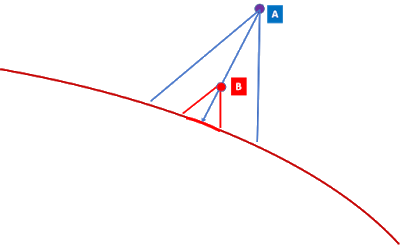
Every satellite has a footprint or the area it covers on the surface of the Earth which is directly proportional to its orbital height. As the satellite passes over the Earth, the location of the footprint changes. The continuous path of the footprint is called a Swath. Satellite A has a larger foot print than Satellite B as shown in the diagram. Hence higher the satellite, greater the foot print. A corollary to this is that, with increase in height and decrease in speed, the satellite stays over the target area for a longer time. Its ability to stay and stare over a larger area increases. As compared to a Geostationary orbit, which has a large footprint which is stationary, a LEO satellite has a small and momentary footprint and can observe / communicate with only a fraction of the Earth at a time. In order to overcome this issue of interrupted coverage LEO satellites are used in a constellation to provide continuous coverage.
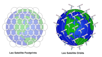 Satellites could be in constellations varying from 2-840. However, in a practical sense any constellation of 12-24 satellites give a fair coverage of an area for surveillance. Which implies that if Pakistan is under surveillance by a constellation consisting o f 12-24 satellites the coverage would be between 3-6 hours in a 24-hour period with a look period of 15 minutes at a time. The intervening periods will have to be correlated or change detection techniques must be used. LEO constellations are more costly and complex to launch and operate.

Launching
Satellites are placed in space by launching a rocket. The higher the height at which a rocket is placed the greater the effort required. Which means a heavy rocket and extensive launching facilities. A LEO satellite requires a very small rocket in comparison to a Geostationary rocket. Also, LEO satellites and space stations are more accessible for crew and servicing.
Segments
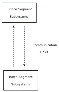
Any Satellite system has a space segment and an earth segment. The space segment consists of the sensor, satellite, power, transmission and control sub systems. Control sub system will be controls of the satellite as well as the sensor. Sensors can be steered, directed or focused as required. The Earth segment consists of the tracking antenna, transmission, downlink/ data receivers, sensor control and orbit control sub systems. The overall mission control also forms part of the Earth Segment.
 Sensors
A satellite is essentially a platform in space which hosts a payload. Theoretically, a LEO satellite can carry any number of sensors as part of its payload. However due to considerations of launch capabilities and on-board power requirement, the sensors are restricted. More sensors imply greater weight. Greater weight implies a more powerful launch. Similarly, power is required to operate the sensors and the satellite controls. A complex sensor needs greater power. As the height increases, the amplifier power requirements increase for signal transmission. This in turn demands more on-board power. Satellites draw solar power and operate with it. To that extent, a LEO in polar orbit is well suited since it is in sun for fifty percent of its orbit and gets recharged repeatedly. However overall power available is a severe limitation. Another aspect is that for a given sensor while the footprint increases with height, the power requirement also increases, and resolution detail decreases. So, this contradictory phenomenon must be reconciled. A major factor is the technology adopted on the sensors. Advanced sensor technologies reduce sensor size, power requirements and weight. This enhances the capability of the satellite. A sensor could be active or passive. A passive sensor uses an external source of energy or the target emissions for detection. An active sensor generates its own energy to either illuminate the target or act upon it. Any satellite will have dedicated and separate communication channels for controlling the satellite, controlling each of the sensors and downloading data from the sensors.
Passive Sensors
Most military sensors fall in the passive category. They use the illumination by the sun or the emissions by the target to detect them. Battle field sensors such as day/night cameras, Thermal Imaging systems, electronic warfare receivers, communication transponders, and meteorological are all passive systems. Communication transponders can be used for Command and Control, Air Space Management, UAV/ Air craft control and enhancing range of communications.
Active Sensors
Active systems are more complex since they must generate some energy to act on the target. Active sensors include any Radars to include Synthetic Aperture Radars, LIDARs, laser-based devices, electronic emissions for jamming, and Directed Energy Weapons. The biggest challenge in an active system is power generation / management and weight management. It must be remembered that energy generation consumes weight and power at a phenomenal rate. In this context, though satellites are spoken of as platforms for Directed Energy Weapons, technologically we are not yet there. USA started the Star Wars Program in the Ronald Reagan era and had to close it down since it was prohibitively costly.
Deployment of Satellites
Deployment of satellites for military purposes must be a well-planned operation. One must be clear well in advance as to what one expects of the satellite or a constellation. Accordingly, payloads must be planned. Remember, once launched, a satellite will be in space for years and its configuration cannot be changed. Also, it is sensible if we can hook in to a GEO / MEO satellite system which will act as an anchor. This is especially useful for communication, navigation and meteorological purposes. In an overall sense military purposes are best served by a constellation of LEO and GEO satellites. The satellites will be in their respective orbits playing their role. The patch up and syncing must be done on ground. Also, adequate redundancy must be built in. Operating a constellation is inbuilt ASAT defence. If one satellite is knocked off all that has happened is that a hole has been punched in the system. A strong adversary will have the capability to replace the lost satellite by an immediate launch. This is a capability India must develop.
Space Debris
The LEO environment is crowded. Hence space Debris is a live problem. The best illustration of this phenomenon is available in the movie Gravity. There must be redundancy for loss of satellites due to space debris collisions.